
Changing Shape of the Cape & Islands: Chatham’s Monomoy Islands and Stage Harbor
Cape Cod Life / April 2017 / History
Writer: Christopher Setterlund / Photographer: Josh Shortsleeve, Kelsey-Kennard Photographers, Paul Andrews, and Paul Rifkin
Changing Shape of the Cape & Islands: Chatham’s Monomoy Islands and Stage Harbor
Cape Cod Life / April 2017 / History
Writer: Christopher Setterlund / Photographer: Josh Shortsleeve, Kelsey-Kennard Photographers, Paul Andrews, and Paul Rifkin
Editor’s note: This is the 13th in a series of articles covering the region’s dramatically changing coastline. Click here to see all of the articles.
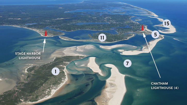
*We have highlighted and numbered 16 locations described in the article to help readers locate them in the photos.*
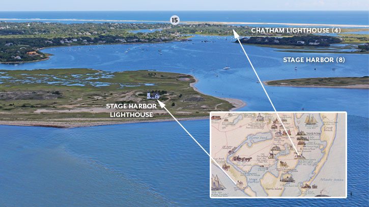
Map courtesy of the Chatham Historical Society. Photograph by Paul Rifkin
To the south of Chatham, the sandy spits that comprise North (1) and South Monomoy (2) Islands measure about eight miles, stretching north and south like fingers or drumsticks. In 2007, following several years of coastal waters picking up sediment and transporting it southward along South Beach Island (3), the island itself connected to South Monomoy. Walkers, were they so inclined, could set out from Chatham Light (4), head across Lighthouse Beach (5), plod southward over several miles of sand, and knock on the front door of the Monomoy Lighthouse (6) keeper’s quarters.
This scenario did not last long, though, for in 2013, South Beach Island was breached (7) about a mile and a half south of Chatham Light, bringing to an end this special lighthouse-to-lighthouse route. Much more than disappointing adventurous walkers, though, erosion, accretion, and other natural changes that have taken place along the coast of Chatham—and Monomoy, specifically—have impacted navigation routes in the area and brought about a major change for nearby Stage Harbor (8).
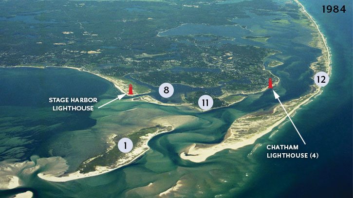
In this 1984 photo, one can observe that Nauset Beach (12) runs along the Cape Cod coastline, unbroken for miles, from near Monomoy to Orleans/Eastham. Fishermen and boaters regularly traveled through the Southway (13) to get from Chatham Harbor to the ocean. Photograph by Kelsey-Kennard Photographers
In this article, we look at the changes that have taken place around Monomoy, both in the last decade as well as the last century, including Monomoy’s transformation from a peninsula to an island—and then two islands.
Monomoy was created in the wake of the last ice age 18,000 years ago, upon the retreat of the glaciers. The size of North and South Monomoy—some 7,604 acres, combined—fluctuates due to the patterns of erosion and accretion. When waves come at Monomoy’s shores from different angles, longshore currents pick up sand and then deposit it further down the coast.
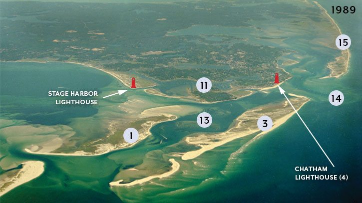
This 1989 photo was taken two years after the 1987 barrier beach breach (14), just east of Chatham Light (4). The event made the southern part of Nauset Beach an island—to be called South Beach Island (3). In the years that followed, the island’s northern tip curled inwards, eventually stretching across to the mainland, forming Lighthouse Beach (5). Photograph by Kelsey-Kennard Photographers
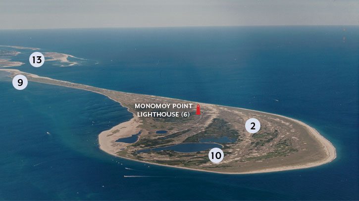
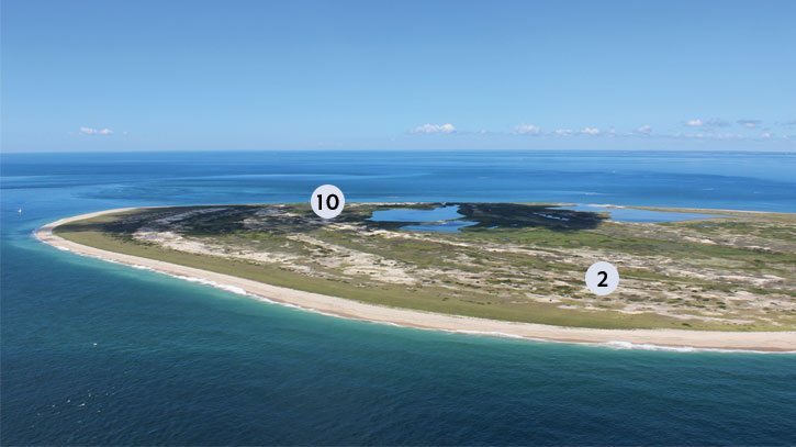
In colonial America, Monomoy was an active settlement. In 1711 locals opened Stewarts Tavern in an area of South Monomoy known today as Inward Point (9). During the 1830s a small fishing community called Whitewash Village (10) thrived near the southern tip of the island; at its peak, the village was home to 200 residents, a schoolhouse, an inn, and two wharves where fishing boats could be supplied. A winter storm in 1860 effectively brought an end to year-round living on the island though. The harbor shoaled in the years that followed, and the village’s fishing business declined. Some houses were moved to the mainland, while others were left to the elements.
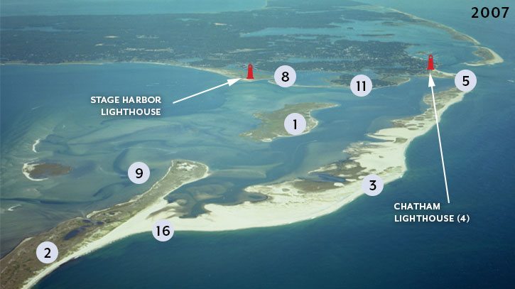
This 2007 photo was taken after South Beach Island (3) connected to South Monomoy (2) at point 16. For a few years, energetic walkers could make their way, by land, from Chatham Light (4) to Monomoy. However, the Southway’s (13) utility as a harbor-to-ocean route was all dried up. Photograph by Kelsey-Kennard Photographers
Ted Keon, Chatham’s director of coastal resources, describes what makes Monomoy’s landscape so unique. “Monomoy is considered the southern sediment sink of the Outer Cape beaches,” Keon says. “There is a very dominant transport of sediment from the ocean waves carrying it south toward Monomoy, which is why the southern end of the island looks like a drumstick.” Illustrating this phenomenon, Monomoy Point Light (6), which was first built in 1823 and at one point stood just 180 feet from the beach, sits a comfortable 1,000 feet inland today. The light has not been moved by man; sand has built up on the shoreline, “moving” the light, in effect, inland.
In 1902, as a result of time and tide, Monomoy Island attached to mainland Chatham at Morris Island (11), part of a cycle that likely commenced decades or centuries before—and one that continues today.
Taken in 2016, this image shows where South Beach Island was breached in 2013 (7). Though the opening runs east to west, the considerable shoaling that has taken place around North Monomoy (1) has made the area a navigation challenge for boaters. Photograph by Kelsey-Kennard Photographers
South Monomoy, looking North East. Photograph by Paul Andrews (1980s)
South Monomoy, looking South West. Photograph by Paul Rifkin (2016)
In 1958, a severe storm once again separated Monomoy from the mainland, creating a breach between the landforms and making Monomoy once again an island. This rift had a powerful effect on Stage Harbor (8), which connects Chatham’s Oyster Pond and Mill Pond to Nantucket Sound. Prior to the breach, the harbor’s entrance was just west of Monomoy, but after the event strong currents flowed through the new channel, inundating the harbor with sediment. Mooring areas filled in, a Coast Guard boathouse was rendered unusable, and drastic action was called for.
In 1962, the U.S. Army Corps of Engineers dug a new entrance to the harbor one-half mile to the west of the original—right through Hardings Beach. The dredging material was used, in part, to create Crescent Beach, a man-made barrier for the harbor; the beach curves eastward from the harbor’s new entrance to Morris Island (11).
During the Blizzard of 1978, Monomoy was split in two, creating North Monomoy and South Monomoy.
Over the years, Chatham’s barrier beach, Nauset Beach (12), continued to stretch south-—to the east of North Monomoy. The waterbody that flowed between them came to be called the Southway (13), a windy but navigable passage that boaters could travel to the ocean. “This was a route where boats could travel between the islands,” Keon says. “It was a relative shortcut from Stage Harbor (8) to the Atlantic, in and out of Nantucket Sound.”
Breaches in Chatham’s barrier beach in 1987 and 2007 created two new inlets—at left, and above—and made North Beach an island. Photograph by Paul Rifkin (2016)
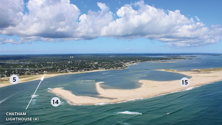
A short distance north, in January of 1987, a nor’easter caused a break (14) in Chatham’s barrier beach, just east of Chatham Light. This created North Beach (15) and South Beach Island (3), the latter of which, as a result of sediment piling up in the ensuing years, would connect to the mainland in 1992. Readers know this connection as Lighthouse Beach (5).
Currents continued to sweep sediment southward, and in 2006 South Beach Island stretched all the way to South Monomoy. Wave action and tidal flow dumped sand in the inlet to the Southway, ultimately clogging the opening and connecting the two sides (16). This was the first time Monomoy was connected to the mainland in half a century, and—as mentioned earlier—a scenic Monomoy-to-mainland walking route was created. Alas, the days of sailing through the Southway were over.
Like other “reunions” highlighted in this story, this one, too, was short-lived: South Beach was breached in February of 2013 (7). The breach measures some 2,000 feet across, creating an opening from ocean to Sound, but Keon says the channel’s use as a navigation shortcut is problematic. “It’s very shallow,” he says, “and difficult to navigate except at high tide.”
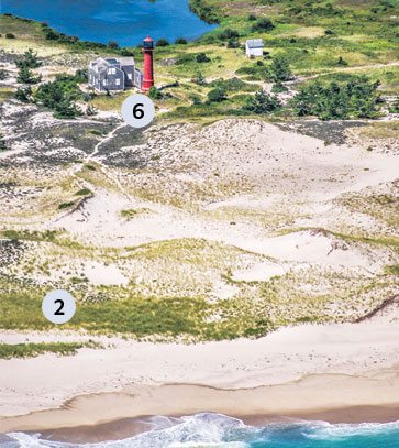
Monomoy Point Lighthouse (6). Though at one time the light stood just 180 feet from the beach, as a result of sand accretion over the years the light is a considerable distance inland today. Photograph by Josh Shortsleeve (2016)
According to Stuart Smith, Chatham’s harbormaster, this breach has also caused more trouble for Stage Harbor (8). “It created additional sand movement,” Smith says. “The sand is moved west through the breach toward the channel and is being dumped into the harbor.” During the past 15 years, Smith says, Stage Harbor has been dredged a few times, adding that another round is overdue. “Boaters that use the channel are generally aware [of the increased sediment],” Smith says. “It’s not like it’s a surprise—what’s surprising is the rate at which it’s shoaling. It continues to be a challenge.”
The changes Monomoy has weathered over the years will continue to occur, Keon says. Having stretched all the way to South Monomoy (2), South Beach (3), Keon says, has thinned out and may be vulnerable to future breaches. “South Beach is eating itself,” he says. “It’s breaking apart as sediment continues being carried south. It’s eroding on the east shore while gaining on the west.” Eventually, the pileup could bring Monomoy and Morris Island back together.
For boaters who wish to explore the waters around Chatham and Monomoy, Smith offers some advice. “Follow the buoys and pay attention to the tides,” he says. “The breaking surf on the shoals can cause trouble. Chatham continues to be a difficult place to navigate, but it’s such a beautiful, pristine place.”
Christopher Setterlund is a freelance writer from South Yarmouth.