
The Changing Shape of the Cape & Islands: The Changing Shape of the Gay Head cliffs, Martha’s Vineyard
Editor’s note: This is the 10th in a series of articles covering the region’s dramatically changing coastline. Click here to see all of the articles.
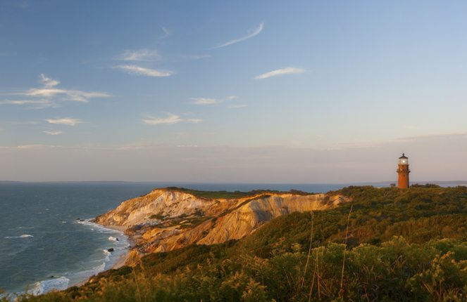
This photo show the historic Gay Head Lighthouse prior to its move back from an eroding cliff face in 2015. Photo courtesy shutterstock/matthew bird
Forty-six feet. In 2014 only 46 feet stood between the historic Gay Head Lighthouse on the west coast of Martha’s Vineyard and a retreating cliff face. Erosion had eaten away at the once ample cliff-side, leaving the historic light in a precarious situation. Racing against time and tide, local residents and community groups got involved, obtaining ownership of the light and raising the funds necessary to move it back from the cliff and out of harm’s way.
The current Gay Head Lighthouse was built in 1852 and completed in 1856. The structure stands along the beautiful clay cliffs in Aquinnah, the Vineyard’s westernmost town. The 52-foot light replaced the area’s first lighthouse, an octagonal wooden structure which was built in 1799 to guide whaling ships and other vessels passing by Gay Head, and to help them steer clear of Devil’s Bridge, a dangerous shoal of boulders that extends northeast off the coast of Aquinnah for about a mile. Even with the lighthouse in place, several ships have been lost in the area over the years, including the 275-foot SS City of Columbus, which ran into the boulders on January 18, 1884. The wreck claimed the lives of 103 passengers and crew—and remains one of the worst maritime disasters in New England history.
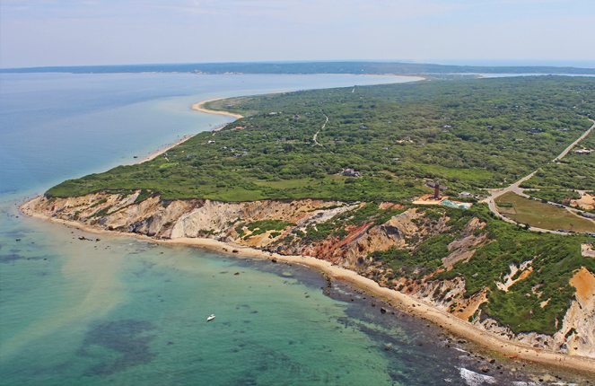
Many are likely aware of the move of Gay Head Light back from the cliff’s edge in 2015, but erosion in the area is nothing new. In 1844, just 45 years after the original light was built, it was moved back 75 feet from the eroding cliffs. That would not solve the problem forever, though. According to research conducted by the Martha’s Vineyard Commission, from 1845 to 1979 the Gay Head cliffs continued to erode at a rate of two and one-half feet per year. In recent years, storms have done a number on the cliffs, often sending large chunks of clay and soil crashing down the cliff.
After the move of the lighthouse. Photo courtesy of Paul Rifkin
Byron Stone, a research geologist with the United States Geological Society, says erosion in this area is not just a factor of wind and waves. “There are freshwater springs located inside of the bluff which drain out along the face,” Stone says. “The fine materials in the layers underground hold up springs the size of soccer fields. The bluff is 120 feet above sea level, and the perched water tables sit between 40 to 70 feet below where the lighthouse stood. The rain seeps down into these tables and can cause landslides of the bluff. The erosion problems are more an issue of the rain above than the waves below.”
As the cliff continued to erode, some in recent decades began to sound the alarm that the lighthouse may have to be moved once again—but first, the structure had to be saved from demolition. In 1985 the Coast Guard planned to tear down the light and replace it with a simple metal pole with a blinking signal. Len Butler, chairman of the Gay Head Light Advisory Board, says this is not uncommon, as six to 12 lighthouses across the country—often lights that no longer are being used as navigational aides—are disposed of each year due to the cost of maintaining them.
Instead of being razed, the light was transferred in 1985, via lease, from the Coast Guard to the Vineyard Environmental Research Institute (VERI), a non-profit organization that conducts oceanographic research including studying the effects of ocean storms on the erosion of the island. VERI was granted ownership rights for 35 years. In 1994, the lease on the light was again transferred, this time to the Martha’s Vineyard Museum. When the Coast Guard deemed the light “surplus property” in 2013, the Town of Aquinnah applied for and was granted outright ownership of the structure, effective in February of 2015.
In 2010 Richard Skidmore, keeper of the light since 1990, was walking on a path along the bluff when he noticed that about 40 feet of fencing had tumbled down the bluff face. The lighthouse needed to be moved—and fast, Skidmore thought. During the 1970s and 1980s, the Army Corps of Engineers had studied the area and concluded that the lighthouse was in danger of falling over the edge within 40 to 50 years. The toppled fence was the wake-up call the community needed.
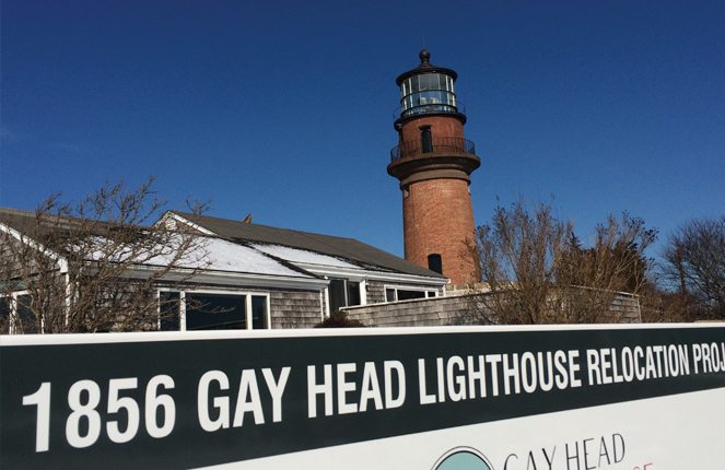
Photo courtesy of Matt Gill
In 2013 the Save the Gay Head Light Committee was formed to oversee the task of procuring ownership of the light from the Coast Guard—and then raising the $3.4 million it would cost to move it. Time was of the essence, Butler recalls. “Thirty-feet of clearance was needed to get the equipment in to excavate around the lighthouse,” Butler says, adding that at that point in 2013 the light stood just 46 feet from the edge. Butler, who also works as a contractor, knew that professionals needed to be called in to move the light because the work, he says, involves “a completely different level of expertise.”
Hired to do the job was the International Chimney Corporation of Williamsville, New York. In business since 1927, the company looks for historical projects to take on, specifically those involving lighthouses. Joe Jakubik manages the company’s historical preservation division—and has overseen some fascinating lighthouse moves, including that of North Carolina’s historic Cape Hatteras Light in 1989. The company also moved both Highland Light in Truro and Nauset Light in Eastham in 1996.
“We learned our lesson with each lighthouse move,” Jakubik says. “With Highland and Nauset, the foundations of the lighthouses came up from the ground with [the structures]. That is not supposed to happen, but you learn as you go. With Gay Head, we got smart and got all the way underneath the lighthouse to account for the foundation. The move went just as planned, but for a few minor machine malfunctions.”
The plan for Gay Head was to move the lighthouse 129 feet back from the cliff along a spine of hard red clay that runs back from the cliff, thus avoiding any potential collapses along the way due to trapped springs underground. The move took three days and was completed on May 30, 2015. According to Butler, the 400-ton structure touched down at its new home without a speck of damage.
With the move complete, Butler says there is still some restoration work, including structural repairs, needed to completely restore Gay Head Light to its 1856 glory. Metal railings were recently installed atop the lighthouse—now open to the public daily—and Butler says more restoration work will continue this fall. In its new location, the light is believed to be out of harm’s way for 150 years.
For Butler, a native of Kentucky who moved to the Vineyard in 1971, this effort to save the light was an accomplishment for all involved. “This is an iconic symbol of the maritime heritage of Martha’s Vineyard,” Butler says. “The light is what first attracted me to the island. Standing here by the cliffs with my wife . . . I knew this was the place I wanted to live.”
Christopher Setterlund is a freelance writer from South Yarmouth.