
The Changing Shape of the Cape & Islands: The tidal flats of Brewster, Orleans, & Eastham
Editor’s note: This is the 11th in a series of articles covering the region’s dramatically changing coastline. Click here to see all of the articles.
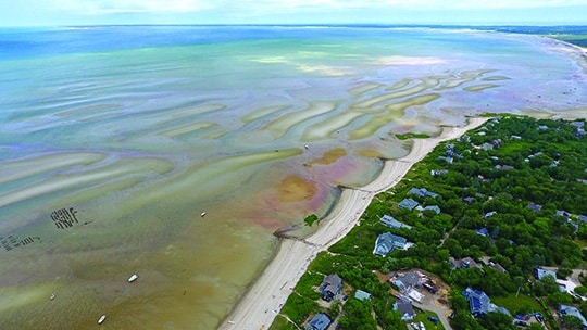
This drone photograph shows Breakwater Beach in Brewster, and looks eastward in the direction of Orleans and Eastham. Photo by Christopher Seufert
Measuring approximately 12,000 acres at low tide, the tidal flats that run along the coastline of Cape Cod Bay are the largest flats in North America. The unique area extends some 9.7 miles along the shore from Brewster to North Eastham. As many beachgoers, nature lovers, walkers, and artists are aware, at low tide portions of the flats extend up to two miles off shore, creating a spectacular, naturally recurring recreation area.
Much like other areas of the Cape as well as Martha’s Vineyard and Nantucket, erosion is affecting the flats and the beaches behind them. In particular, areas such as Skaket Beach in Orleans and Breakwater Beach and Paine’s Creek in Brewster have felt the effects.
In Orleans, officials have been keeping a close eye on Skaket Beach. In recent years, the east end of the popular beach has been losing three to four inches annually due to erosion, while the west end, near Namskaket Creek, has been losing almost five feet per year.
Dawson Farber, harbormaster for the Town of Dennis who served in the same role for the Town of Orleans from 1996 to 2014, adds insight on what is happening. “If you think of Cape Cod as an arm, Orleans is the hook of the elbow,” Farber says. “There is a lot of energy forced into that area, especially in the fall and winter when the storm winds come from the northwest.” The wind eats away at the protective sand dunes at Skaket, with the sediment either getting pulled back and deposited onto the tidal flats, or pushed forward and ending up coating the beach’s parking lot.
This scenario has played out annually for the past decade, but Farber says the erosion has worsened in the past five to seven years—and the town has often paid to scrape up the sand and redeposit it back on the beach. About 10 years ago, Farber says the sand would often be pushed the other way, ending up on the flats.
To re-nourish the dunes, the Town of Orleans has purchased sand to shore up the damaged areas, and from 2000 to 2010 acquired permitting so that front-end loaders could drive out onto the flats to retrieve sand that had been pulled from the beach. This latter effort was halted when beachgoers complained, Farber says, “that the sand wasn’t the same color as the rest of the beach.” In both scenarios, Farber recalls times when the entirety of the “re-nourishment sand” would be washed back onto the flats in a single storm.
A half-mile to the west, the area around Namskaket Creek—which serves as a natural border between Orleans and Brewster—has also seen a tremendous loss of coastline in recent decades. “From 1995 to 2005 there was a loss of 30 to 40 feet of coastal embankment [on the Orleans side], with some spots losing as much as 50 feet,” Farber says. He adds that a few cottages built along the embankment had to be relocated in 1996.
Further west, beaches in Brewster are experiencing similar issues. Chris Miller, director of Brewster’s department of natural resources, has seen the town’s coastline transformed drastically during his eight-plus years on the job. He says the main problem areas are Breakwater Beach and Paine’s Creek, and the latter’s biggest issue involves the parking lot.
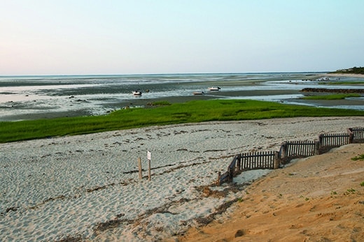
Breakwater Beach, Brewster. Photo by Charles Sternaimolo
In the 1970s and 1980s, the Paine’s Creek parking lot had spaces for about 45 vehicles, but that amount has dwindled. “In the last few years it was down to 15 spots,” Miller says. “It was a difficult spot to fix with it being next to the creek.” The town initially moved the parking lot back from the shoreline, and built a culvert to help divert some water that storms were pushing into the creek into nearby Freemans Pond instead. These efforts have helped to restore the area, Miller says.
The changes taking place at Breakwater Beach have been a topic of discussion in Brewster for several years. A number of severe winter storms, beginning with a blizzard in February of 2010, have heavily eroded the beach. In just six years, 20 feet of beach (at high tide) has been lost, threatening the parking lot. Remedies proposed to address the situation have been hotly debated in town because a number of homes surround the beach.
In 2015, a proposal to move the parking lot back 120 feet was approved by the town of Brewster. As part of the project—which was to be completed in July—the dunes were to be built up and supported with beach grass and other vegetation. The project was paid for by a $155,000 grant and $59,675 from the town’s Community Preservation Act funds.
Now—whereas Paine’s Creek and Breakwater Beach are losing sand due to erosion—there are areas at the east end of Brewster and in Orleans, particularly on the flats, that are gaining it. “There is an erosion loss of one to two feet per year at one end of town,” Miller says, “but areas off the east end of town, like Namskaket, Linnell Landing, Crosby Landing, and into Rock Harbor . . . in those areas the flats are rising.” According to Miller, sand is arriving to the area from beaches to the west, and from Provincetown to the north—and in some spots it’s piling up.
Reflecting on erosion both Miller and Farber commented that local decision makers should put a lot of thought into whatever resolution efforts they decide on—and on how those remedies could affect the region down the road.
“Shoreline hardening projects like jetties and retaining walls act as sand traps,” Farber says. “They create a beach around where they are built, but they rob places down-current of sand. Consideration must be given to those down-drift.” Many would argue the scenario Farber describes fits to a tee the situation that has played out over the past century at Town Neck Beach in Sandwich, which is just down-drift from the jetties stretching out from the Cape Cod Canal’s eastern entrance. Whereas Town Neck Beach to the south of the jetties has been losing sand, Scusset Beach to the north is gaining it.
Miller says dealing with erosion is a public process, and that change can be, at times, hard to accept. “There is always storm damage,” he says. “There are parking lots to restore and beaches to re-nourish. [Addressing erosion] is a matter of long-term planning and staying ahead of the curve. Everything takes time.”
Christopher Setterlund is a freelance writer from South Yarmouth.