The Changing Shape of the Cape & Islands: Wellfleet Harbor

Editor’s note: This is the 12th in a series of articles covering the region’s dramatically changing coastline. Click here to see all of the articles. Click here to see all of the articles.

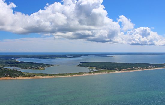
Looking eastward, this recent aerial photo shows Great Island, Wellfleet Harbor, the Wellfleet mainland, and the Atlantic beyond. At left in the image, one can see Griffin Island, the Herring River, and the Chequessett Neck Road dike. Photo by Josh Shortsleeve
Did you know that just over a century ago there was an island off the bay side coast of Wellfleet? It’s true! At its peak in the mid-1800s, as many as 80 people lived on the island, which held a lighthouse, a school, and about 30 homes. Today, the island of Billingsgate is relegated to the pages of Cape Cod history, yet at low tide the Billingsgate Shoal reappears to boaters traveling in the area in the form of several acres of soggy, sandy land and occasionally a few bricks from the lighthouse’s foundation.
Time and tide sentenced Billingsgate to its waterlogged fate several decades ago, but in modern day Wellfleet the effect of the tides and the process of erosion continues, moving sand hither and yon, trimming back shorelines, and slightly but continually transforming the town’s coastal shape and footprint. Though several of Wellfleet’s Atlantic-facing beaches have experienced a good deal of beach loss as well as an undermining of the dunes in recent years, in this article we focus on Wellfleet Harbor, where coastal change has come in different forms.
To begin, Great Island, a peninsula that serves as Wellfleet Harbor’s western border, was once an island to itself—dating back as late as 1831. Over the years, currents in Cape Cod Bay moved sediment to the area from bayside beaches in Provincetown and Truro, eventually connecting Great Island—and two other islands, Beach and Griffin—by sand to the mainland. Today, the narrow strip of beach, dune, and marsh that connects Great Island to the mainland is known as The Gut, and it provides walkers (and cyclists with beach tires) access to trails in the woods and along the beach.
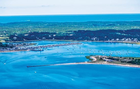
North of Great Island, the Herring River flows into Wellfleet Harbor, also bringing a fair share of sediment, which it dumps into the harbor. As a result, Wellfleet Harbormaster Michael Flanagan says the harbor is currently choking to the point of nonexistence at low tide. Making matters worse, according to a Woods Hole Oceanographic Institute study conducted from 1989 to 1992, the harbor’s incoming tide is stronger than its ebb tide. This means that much of the sediment brought in from the ocean remains in the harbor.
Flanagan explains the situation Wellfleet boaters and fishermen are facing. “For four hours, twice per day—in the time around low tide—the harbor is unusable,” he says. “There is no water due to the silt coming in from multiple areas.” Flanagan says the harbor is basically unnavigable for eight hours, more or less, each day.

Time and tide sentenced Billingsgate to its waterlogged fate several decades ago, but in modern day Wellfleet the process of erosion continues. Photo by Josh Shortsleeve
The harbor was last dredged in 2001 and 2002, but Flanagan says officials are working on permitting for a multi-million dollar dredging project that could get underway as early as 2017. “We need big-time dredging,” Flanagan says. “Hopefully after that we can have periodic maintenance dredging of the harbor, ideally once every 10 years.” He concedes that the effort is likely to take a good amount of time, as studies of the area would have to be conducted before any work begins. Until then, the harbormaster advises boaters to make note of the tides and plan accordingly.
The changes taking place in the harbor and along Wellfleet’s beaches are ongoing situations. The story of Billingsgate Island, though, is an end result of erosion’s effects on an area, even when attempts are made to stave it off.
Billingsgate has been called “Cape Cod’s Atlantis” because during the mid-to-late 19th century it was a bustling community—and today it’s no more. In addition to the homes and the lighthouse, during the mid-1800s the island, located about one-and-one-half miles south of Great Island’s Jeremy Point, had a plant where oil was rendered from the blackfish or pilot whales caught nearby.
Dating back to at least 1855, Billingsgate’s lighthouse—first built in 1822—was under threat from the sea. The whipping winds and waves routinely flooded the light tower in five feet of water. The original light was replaced in 1858, but the threat persisted. In 1888, in a massive effort to preserve the community, some 1,000 feet of jetties and bulkheads were installed and built around the island.
By 1915, however, the once thriving area had dwindled to just two residents: one lighthouse keeper and a watchman guarding the oyster beds. That same year, the lens and lamp were removed from the lighthouse, and the day after Christmas the structure toppled in a storm. The light shone on from a steel-framed tower for seven more years, but by 1922 only five acres of land remained above water, and the light was discontinued. By 1942 the island had been claimed by the sea, and today it’s only briefly visible at low tide.
In Wellfleet, Suzanne Thomas, the town’s beach administrator, says plans to deal with an ever-filling harbor, and crumbling dune faces and endangered parking lots along the Atlantic-facing beaches, are not attempts to “stop” erosion. “Erosion is a natural and ongoing process,” Thomas says, “and human attempts to ‘repair’ or ‘prevent’ it usually fail or even further damage the resource. We accommodate it; we don’t stop it. We always have to take the long view—20 to 30 years out—when dealing with the effects. We can’t stop the process, but we can plan for our reaction to it.”
Christopher Setterlund is a freelance writer from South Yarmouth.


