
The Changing Shape of the Cape & Islands: Lewis Bay, from Hyannis Port to Kalmus Beach & Great Island
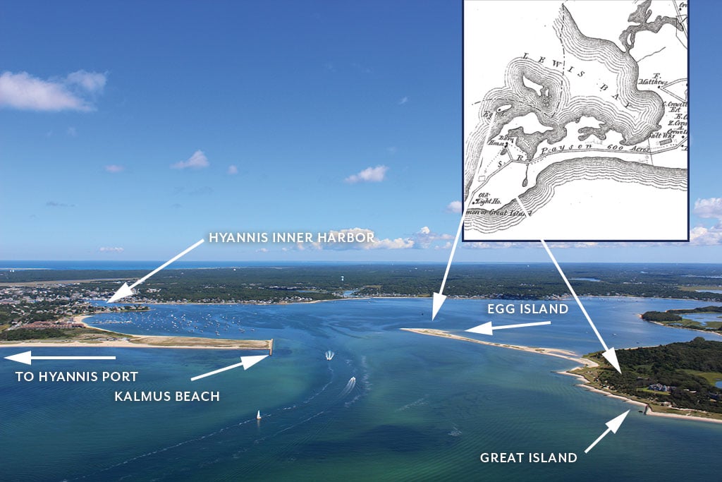
A recent northeast-facing view of Lewis Bay, a busy body of water that serves as the natural border between Barnstable and Yarmouth. Boats can be seen traveling in and out of the bay to Nantucket Sound through the federal navigation channel. Above, one can view Kalmus Beach, the Hyannis Yacht Club, and the entrance into Hyannis’ Inner Harbor, while at right, one can see Egg Island, which is part of Barnstable, and Great Island, a privately owned section of Yarmouth. In the 19th century map, Egg Island and other islands stand on their own in the bay. 1880 map courtesy of the Historical Society of Old Yarmouth. Photo by Paul Rifkin
Lewis Bay is part of the south coast of Cape Cod, basically the center of the triceps when thinking of the “arm” of Cape Cod. The bay measures some 1.6 square miles and serves as a natural border between Yarmouth to the east and Hyannis to the west. Those who travel on ferries out of Hyannis travel through Lewis Bay to get to Nantucket Sound, passing Hyannis’ Kalmus Beach and Yarmouth’s Great Island. The bay is named for Jonathan Lewis, an 18th-century Cape Codder who was the first Hyannis resident to construct a two story home.
As the Steamship Authority and Hy-Line both run ferries in and out of Hyannis’ Inner Harbor, the bay is a busy transportation channel. Brian Braginton-Smith, executive director of the Lewis Bay Research Center, describes Lewis Bay as a “lifeline” connecting Cape Cod and the islands. He also describes the bay’s geography as “like a shallow bowl. The waves wash up on shore, then reverberate back and forth.” It’s the regular use of this “lifeline” that has brought about substantive changes in the “shallow bowl” during the past 70 years.
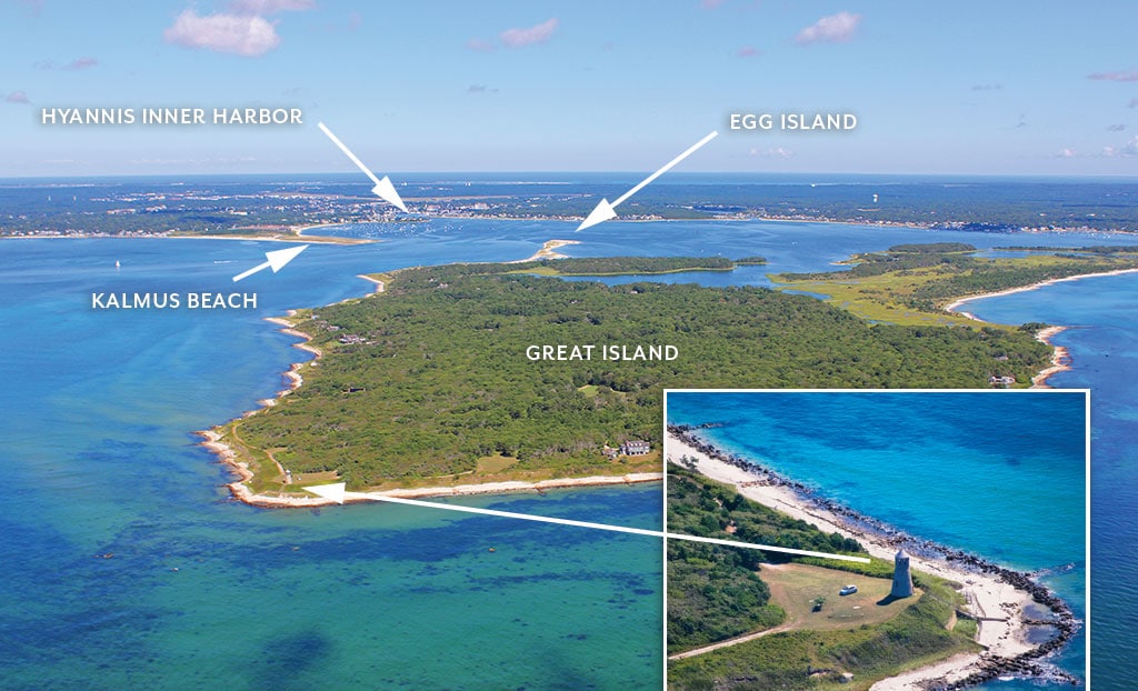
Aerial views of Yarmouth’s Great Island, looking northwest, and Point Gammon Light, located on the southern tip of the island. Main photo by Paul Rifkin. Inset photo by Josh Shortsleeve
“Two fundamental things have resulted in a wholesale dynamic change to the entire ecosystem of the bay,” “Two fundamental things have resulted in a wholesale dynamic change to the entire ecosystem of the bay,” Braginton-Smith says. “The first is the population growth around the bay and the resulting reliance of onsite septic systems. The second is the federal navigation channel.” The route ships travel from the Sound to the Inner Harbor was in 1940 designated a federal navigation channel, Braginton-Smith says, so federal funds could be acquired to dig a deeper, wider channel into Hyannis to further expand it as a port. Naturally, the larger channel allowed for more water to flow in and out of the harbor.
Dan Horn, Barnstable’s harbormaster, says this has caused some problems. “The flood tide coming in from the Sound is stronger than the ebb tide going out,” Horn says. “More water is being pushed into the harbor. This stirs up sediment and leads to shoaling. It has been a gradual process and it’s a mixture of natural and manmade causes.”
According to Braginton-Smith, the increase in tidal flow has caused some damage to the local ecosystem. He recalls the bay’s scallop harvest in 1965 yielding 1,500 bushels, while in 2016 that amount had dwindled to just 100. He says the vessel traffic that’s grown steadily since the channel was expanded has increased wave action in the bay to a scenario underwater that’s comparable to “an intermittent (when the boats are going by) mid-level storm.” And Horn adds, the harbor is home to more than 1,000 boats—especially during the summer.
Horn says the boating traffic has contributed to the intense shoaling in the Inner Harbor. The channel, which is maintained by the U.S. Army Corps of Engineers, was last dredged in 2013. Though Horn says it’s in pretty good shape today, he says there are a few spots that may soon need a touch-up.
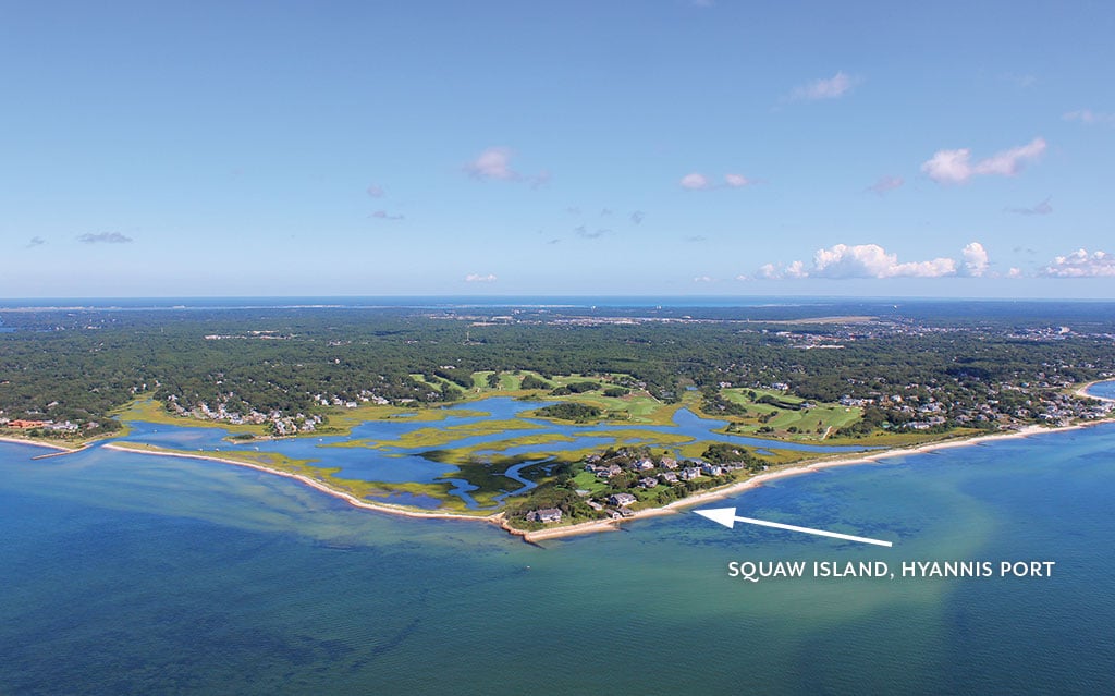
Photo by Paul Rifkin
To the south and east of Lewis Bay one finds Great Island, a 700-acre swath of land extending westward from Yarmouth. Though technically an island, at low tide one could walk from one land mass to the other without getting wet. It’s not recommended, though; the island is privately owned.
In 1802, a small pox inoculation hospital was established at the island’s southern tip, in the area known today as Point Gammon. In the 1880s, a wealthy ornithologist purchased the island and transformed it into a rare game preserve. In 1914, Rhode Island banker Malcolm G. Chace bought the island—and the property remains in the Chace family’s possession today.
According to Horn, the shoaling in Lewis Bay has affected Great Island, at least in its relationship to Egg Island. Since maps of the area have been drawn, Egg Island, a thin five-acre island off the coast of Great Island has stood on its own in the bay. In 2010, though, shoaling in the area brought the islands together. Due to its location, Egg Island is part of Barnstable, while Great Island is in Yarmouth—and as mentioned, it’s privately owned. Horn says some boaters that have beached their vessels at or near Egg Island in recent years report having been asked to move by folks on Great Island.
Across the bay, Kalmus Beach is a natural barrier that protects the Inner Harbor. Named for Herbert T. Kalmus, who once owned Centerville’s Fernbrook estate and who donated the land to the town of Barnstable, the peninsula extends 1,300 feet eastward into the bay.
When the channel was dredged in 1985, the Army Corps of Engineers used some of the dregs to shore up two acres of Kalmus Beach that had eroded. In 1997-1998, a more expansive “re-nourishment” effort covered 75 percent of Kalmus in dredged sediment. Since then, however, Horn says wind and waves have nibbled away at these efforts, dumping some of the newer sediment into the bay just north of the beach, creating a somewhat unnatural shoal.
Both Braginton-Smith and Horn commented that with Lewis Bay’s importance as a transportation “lifeline” there is only so much that can be done to stem some of the bay’s traffic-generated shoaling.
“I’m conflicted,” Braginton-Smith says. “One possible solution could be fewer ferry trips into the harbor, but I love watching those ferries come in past Bayview Beach in Yarmouth.”
“Without regular dredging, shoaling will continue,” Horn adds. “We may want to consider restricting speed limits in the harbor. However, shoaling is mostly a natural process. Even if we didn’t have boats coming in and out there would still be shoaling.” Were the main channel not routinely dredged, Horn says many boats and ferries would find it increasingly challenging to access the bay.